INTRODUCTION

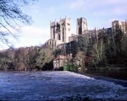
"County Durham is one of the least-known parts of England. Those in search of the rugged north go to Northumberland and Scotland, those who want moors and dales to the West Riding and Cumberland or the High Peak, those who like to see the waves of the sea break against precipitous cliffs to Devon or Cornwall. Durham Cathedral, it is true, means something to everyone, but how many who have seen it from the train to Scotland appearing suddenly, like a mirage in its improbable splendour, have stopped to spend a day in and around it? And as for the stretch of land between Durham and the dales and Durham and the sea, the impassioned propaganda of the late Ellen Wilkinson in the black early thirties has, it seems, in peoples's minds, given them an indelible stamp of squalor and desoalation.
Wrongly so. The county can indeed complain of a lack neither of beauty nor of variety of landscape. The fells of the west, rugged above the Derwent Valley and Weardale, more gently below Teesdale, and the cliffs between South Shields and Sunderland, High force, and the Marsden Rocks have already been alluded to, but there are in addition the deeply eroded, thickly foliated denes stretching down to the sea, the nicely wooded valley around Durham, and the lush agricultural plain around Darlington. Almost everywhere, outside the big conurbations, industry is near to woods and fields."
The Buildings Of England, County Durham. Nikolaus Pevsner. 1983.
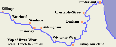
The River Wear flows through County Durham for the whole of its course. It has its source in the East Pennines on Alston Moor near the A689, the highest main road in England, where the Killhope Burn begins its flow to join the Burnhope Burn at Wearhead to form the River Wear proper. The river then passes through farmland to St John's Chapel, Daddry Shield and Eastgate, and on to the small town of Stanhope situated in a deep valley with steep hills rising on either side. Then on to Frosterley and Wolsingham after which the river turns southeast to Witton-le-Wear. From here it winds its way towards the town of Bishop Auckland. Thence it never ceases to wind, progressing in a series of loops to the sea, first turning north for Durham, then north east. In the old city of Durham the Wear winds itself around the hill on which stand the Norman Cathedral and Castle. Continuing its winding course to the north the river passes through former coal-mining country and past medieval Finchale Priory towards the town of Chester-le-Street and Lambton Castle, then moving on to Fatfield and to its eventual outlet in the North Sea at the City of Sunderland.
There are many bridges, footbridges, and viaducts of all types along the Wear and the river is remarkable for the number of former bridges which have benn washed away or damaged by floods and for its many fords. Not a few ferries once croseed its waters.
The River Wear has its source at Wearhead but for the purposes of this website it is explored from the river mouth at the City of Sunderland, moving up river to the ancient City of Durham, then south to Bishop Auckland and north west to Stanhope. It continues west to its source at Wearhead where two tributaries meet. The larger of these, the Killhope Burn is also incorporated into the website, from Wearhead to its source near Killhope Cross, high on the moors where County Durham meets Northumberland and Cumbria.
The website is split into sections, beginning with the bridges between the river mouth and Fatfield, then from there to Chester-le-Street, then on to Durham and so to Bishop Auckland. From there it goes to Frosterley, then Stanhope, Daddry Shield and Wearhead, before the final section up to Killhope Head. Then come pages about former bridges which no longer exist, fords and ferries and finally a list of references and links to other websites which may be of interest.

E-mail --> mm002a1779@blueyonder.co.uk

