INTRODUCTION

"The Tweed is simultaneously England's most northerly river and Scotland's most southerly on its eastern seaboard, and harbour facilities which were developed at its mouth served both countries; Berwick lies almost equidistant from the rivers Forth and Tyne."
Ports and Harbours of Northumberland. Stafford Linsley. 2005.
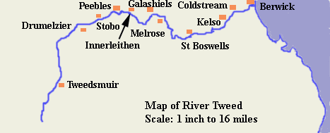
The River Tweed is Scotland's fourth longest river at 96 miles. It rises at Tweed's Well deep in the hills of Peeblesshire, now part of the Borders Region. From there it flows north alongside the A701 road with hills and forests on either side and it is crossed by many small bridges before turning north east amid a less rugged countryside to reach the county town of Peebles. From here it winds its way east through Walkerburn and Innerleithen along pleasantly wooded banks where just north of Selkirk it is joined by the Ettrick Water flowing in from the south west. Passing Galashiels and Melrose it moves south to St Boswells from where it begins a series of loops, then passing through farmland to the towns of Kelso and Coldstream. On the final stretch to the North Sea it turns north to Norham and Horncliffe and finally turning east until it flows under Berwick's four bridges to the Morth Sea. From five miles before reaching Coldtream it forms the border between England and Scotland for all but the last four miles, after which it runs entirely within England. The Tweed is one of the great salmon rivers of Britain. It has many tributaries.
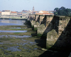
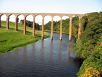
The Tweed has a variety of bridges, many of them tiny, spanning the narrow river in its remote early stages, but later come some ancient stone crossings and a number of disused railway bridges which have survived to grace the Tweed. Berwick and Tweedmouth are linked first by the mighty Royal Border bridge which carries the East Caost Main Line to Edinburgh and then by the more modern road bridge and finally the old Berwick Bridge cross the river.
The River Tweed has its source in the hills of Peebleshire at Tweed's Well but for the purposes of this website it is explored from the river mouth at the town of Berwick upon Tweed in Northumberland, moving southwards to the Scottish town of Coldstream, then continuing eastwards to Kelso, St Boswells, Melrose and Galashiels. It then passes close to the town of Selkirk and on to Peebles where it soon turns south again, becoming ever more narrow until reaching its source in Tweeddale a few miles north of Moffat.
The website is split into sections, beginning with the bridges between the river mouth and Coldstream, then from there to Leaderfoot near Melrose, then on to Walkerburn near Innerleithen and so to Peebles. The final two long sections go to Patervan and then continue through the remote hills to Tweed's Well. Then come pages about former bridges which no longer exist, fords and ferries, and finally a list of references and links to other websites which may be of interest.

E-mail --> mm002a1779@blueyonder.co.uk

