FORMER BRIDGES AND FORDS

Over the years some bridges have been destroyed by floodwaters or have been replaced as they became dangerous or inadequate for modern traffic and some details of these bridges are shown. Footbridges, the first bridges to replace the fords which preceded them, came and went as the need for crossing points changed. There were once several fords but none remain. The coming of the Derwent Valley railway provided a major crop of new bridges and there are now several disused railway bridges on the Derwent, but all have been saved to become part of the Derwent Walk and are popular with walkers, cyclists and horse riders alike.
There are no pictures of most of the former bridges, except for those shown here. The Clockburn Drift bridge was built when the two mile drift tunnel opened in 1948 and it linked Marley Hill colliery with the railway across the Derwent at Winlaton Mill which then ran down to the nearby Derwenthaugh coke works and on to Derwenthaugh itself. Coal was removed by trains small enough to pass through the tunnel using 3ft 6in gauge tracks to the Clockburn site where coal was transferred to standard gauge trains for the remainder of the journey to the coke works. It was located just upstream from the Butterfly Bridge.
- BRIDGES
- Derwenthaugh railway bridge, wooden - 1837.
- Swalwell footbridge, site of Hikey Bridge - date not known.
- Eel's Haugh footbridge at Winlaton Mill - 1842.
- Clockburn Drift NCB railway bridge - 1948.
- Another NCB bridge existed near the site of the new stone bridge called the Derwent Park Bridge - no details known.
- Rowlands Gill road bridge - date not known.
- Rowlands Gill wagonway bridge, at Cowford, next to road bridge. wooden - about 1739
- Lintzford, wooden bridge - destroyed in flood 1828.
- Blackhall Mill road bridge - 1896.
- Blackhall Mill, footbridge, just west of present road bridge - date not known.
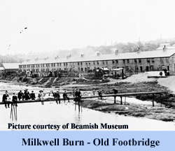
- Blackhall Mill, near Milkwell Burn, footbridge, to Hamsterley Mill Colliery - date not known.
- Blackhall Mill, footbridge, west of Low Westwood at bend of river.
- Ebchester Roman bridge, probably stone piers with wooden roadway - date not known.
- Shotley Bridge - Papermill Bridge or Iron Bridge, footbridge, 1890s?
- Allensford road bridge, narrow two-arched, stone - 19th century, replaced in 1925.
- Allensford road bridge, concrete and iron, widened in late 20th century - originally 1925.
- Snape End, footbridge - SE of Muggleswick and W of Crooked Oak - date not known.
- Eddy's Bridge road bridge, stone, one segmental arch, originally 19th century - rebuilt 1901.
- Mill Shield, footbridge - N of Edmundbyers, - date not known, now under Derwent Reservoir.
- Espershields bridge (or Cowperhaugh bridge), minor road S - 1869, replaced 1941?, flooded by Derwent Reserovir.
- Bay bridge, footbridge, 200 yards W of road bridge - date not known.


- FORDS AND A FERRY
- Swalwell - a ferry existed in the mid-19th century 300 yards upstream from the Derwent mouth.
- Swalwell - west of Hikey Bridge.
- Blackhall Mill - at Milkwell Burn.
- Snape End - SE of Muggleswick and W of Crooked Oak, and stepping stones N of here.
- Eddy's Bridge.
- Roughside, W of village.
